See photos of Bremanger on Google Images →
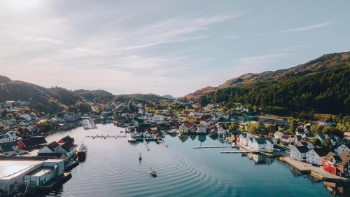
Bremanger is Norway’s coastal kaleidoscope - a municipality in Vestland county where **Europe’s highest sea cliff**, white-sand beaches, Viking legends, and Stone Age carvings all collide in spectacular fashion. With around 3,500 residents and a landscape that stretches from glacier-topped peaks to emerald fjords, Bremanger is often dubbed “Little Lofoten” for its dramatic scenery and vibrant coastal culture. It’s a place where nature and history don’t just coexist - they perform a duet.
Top Attractions
Hornelen
Europe’s tallest sea cliff (860m)
See on Tripadvisor · 📍
Vetvika
hidden beach with turquoise waters
See on Tripadvisor · 📍
Grotlesanden
postcard-perfect white sand beach
See on Tripadvisor · 📍
Vingen
7,000-year-old rock carvings (guided only)
See on Tripadvisor · 📍
Kalvåg
historic wharfside village with rorbu stays
See on Tripadvisor · 📍
Booking a flight? Not sure which airport is closest to Bremanger? Copy the prompt and ask Kayak AI for the smartest route into town.
What is the nearest airport to Bremanger, Norway, and the best way to get from the airport to Bremanger?Unique Experiences
Ålfotbreen glacier viewpoints
Visit the westernmost glacier’s lower slopes and named Gjegnen viewpoints for a landscape shaped by ice unique to Bremanger.
See on Tripadvisor · 📍
Svelgen industrial heritage trail
Explore Svelgen’s 20th‑century hydropower and smelting sites with local interpretation about how industry transformed the fjord community.
See on Tripadvisor · 📍
Trollholet sea‑cave visit
See the locally named Trollholet and nearby blowholes: compact, dramatic sea‑carved chambers found along Bremanger’s exposed coast.
See on Tripadvisor · 📍
Bremangerlandet photography route
Follow the island‑cluster route from Iglandsvik to small fishing hamlets, sea‑polished gneiss outcrops, and skerry viewpoints prized by photographers.
See on Tripadvisor · 📍
Rugsund Bridge and hamlet walk
Walk the historic hamlet streets and bridge viewpoints at Rugsund for intimate views of local coastal life and narrow fjord channels.
See on Tripadvisor · 📍

Where to Stay in Bremanger




Getting There
Bremanger is accessible by car via the Bortne Tunnel and Skatestraum Tunnel, or by ferry from Oldeide to Måløy. Express boats connect Kalvåg and Smørhamn to Florø and Bergen. The nearest airport is Florø (FRO), and buses run to Svelgen, the administrative center. Local roads and hiking trails link villages like Berle, Rugsund, and Ålfoten.